Friday, December 9, 2011

Yarmouth’s Community Music Center had a peg-leg ghost and a bomb shelter when I bought the place.

 My focus today is on a Yarmouth landmark, the sea captain’s mansion built by Sylvanus C. Blanchard in 1856. Now called “317 Main Street,” the historic house has been transformed into a cultural crossroads featuring art exhibits, music lessons and concerts. Over the years, the mansion has also served as a boarding house, a lumber yard, a bomb shelter and my wife’s yarn store called, “Martha Hall.” When we purchased the house in1979, she was looking for a great business location while I was chasing stories of ghosts and fascinated by the rooftop “widow’s walk.” As usual her judgment was considerably more astute than mine.

 Just as we were signing the papers to buy the building, the former owner’s wife blurted out that the place was haunted. Over her husband’s protests, she insisted that we would see strange lights and hear a peg-legged sea captain thumping around at night. Despite the many eerie noises in the old house, I soon learned that neither of the two sea captains who lived there had lost any limbs nor had they expired in the building. If you look closely at today’s photograph, you will see the house as it appeared in the 1880’s. Based on another photo that I have seen, the gentleman in the top hat is almost certainly the owner, Captain Eben York.
 
 By the time he retired and purchased the house in 1881, Eben York had commanded some of the Blanchard family’s largest ships. The managing partner of that family-owned shipping business was S.C. Blanchard, the captain who built the house in 1856. Like many Yarmouth mariners, Captain Blanchard had ridden the great wave of prosperity that flowed into Yarmouth before the Civil War. Blanchard ships carried goods like cotton and guano to Europe and hides from South America to New England’s shoe factories. It is very likely that the leather trade brought S.C. Blanchard into contact with the wealthy Portland traders, Andrew and Samuel Spring. In 1855 they hired the talented Portland architect Charles A. Alexander to design their adjacent homes on Danforth Street. Highly regarded for his use of the popular new Italianate style, Charles Alexander’s commissions included the Chestnut Street Church that is now the trendy Portland restaurant, “Grace.”

 In 1856 Captain Blanchard followed the example of the Springs and asked Charles Alexander to design a stylish house that is now 317 Main Street. With marble fireplaces, plaster cupids on the ceiling and a two story outhouse, the elegant home also served as Captain Blanchard’s office and made a bold public statement about his wealth, power and social status. Within two years Blanchard was elected to the state legislature where he offered a dubious proposal to send emancipated slaves back to Africa in Blanchard-built ships. During the Civil War Blanchard sold the house and moved to Boston. Returning when shipbuilding revived in the late 1870’s, he ordered up a new mansion (now 261 Main St.). He had barely occupied that place when financial disaster struck. Running from his creditors, he died in 1888 in a hotel in Richmond, Virginia.

 Although I wasn’t terribly surprised when the handicapped ghosts failed to appear in the old house, I confess that I was a true believer in the idea of a widow’s walk. Somewhere along the way I had heard that the towers and cupolas on sea captains’ homes were designed to give their wives a spyglass view of the sea. From this perch a woman would faithfully watch for her husband’s ship to come sailing home. To test this romantic notion, I grabbed my old brass telescope and clambered up the hidden stairway to Captain Blanchard’s cupola. Alas, I quickly discovered that neither the river nor any patch of Casco Bay was ever visible from the house. With nothing but Wescustogo Hill and Bradbury Mountain to show for my effort, I reluctantly accepted the fact that cupolas on Italianate homes are just another stylistic feature like overhanging roofs, arched windows and bold roof brackets.

 I loved living in that house, in part because I kept stumbling across the traces of those who had been there before me. For example there was an Irish maid who lived in one of the rooms near the barn. I discovered her name tucked into S.C. Blanchard’s family in the census of 1860. Behind the barn I dug up an a silver spoon engraved with the initials of Captain Eben York’s wife. On another occasion when we were installing a new door, we discovered the initials “AWC” boldly inscribed in a layer of plaster inside the original wall. Since then I’ve found strong evidence that this was Augustus W. Corliss who did more than any other person to preserve Yarmouth’s early history. And, of course, there was Hazel Hilton and her bomb shelter. It’s a good thing she wasn’t standing in it during a real air raid. Hastily constructed during the Cuban missile crisis, the shelter’s concrete block roof had completely collapsed onto the cellar floor by the time I first saw it in 1979. All in all, these memories have convinced me that the old house really is full of some delightful ghosts, even if they do not thump around in the middle of the night.

 Today’s photograph of the S.C. Blanchard house is from my own collection of Yarmouth photographs. The following picture shows the building when my wife Martha had her yarn shop.

Friday, November 18, 2011

A grandiose scheme by the “Electric Railroad King” led to the creation of South Freeport’s Casco Castle

 My focus today is on a wintry scene in South Freeport around 1905. Although I always find it amazing that a stone castle pokes up over that pretty little village, it was the trolley car that caught my attention. Since the Casco Castle hotel (in the background) was operated only in the summer, I have to wonder why the trolley has stopped. Are there actually some intrepid trolley passengers who want to slip and slide across the 100 yard long suspension bridge to a shuttered resort?

South Freeport’s famous castle was built by a trolley car line.
The photograph raises deeper questions about the cozy connection between interurban “electric railroads” and the creation of leisure destinations in the early1900’s. Around that time many seaside resorts and “trolley parks” like the Casco Castle were constructed to provide an opportunity for city-dwellers to escape into the leafy “borderlands” outside the city. This trend raises a chicken and egg question about which development came first––the trolleys or the hotels––and the answer goes back to the Chicago World’s Fair of 1893. That was where Americans fell in love with the idea of electricity.

By the middle of the 1890’s entrepreneurs such as Amos Gerald (Maine’s “electric railroad king”) realized that electrically powered interurban trolleys could link together regions that were not well served by traditional railroads. They knew that those lines might eventually turn a profit from commuters who would move into the leafy borderlands around cities. However, at the beginning of this venture, entrepreneurs like Gerald faced the opposite problem of trying to lure crowds out of the city and into their trolley cars. Since the companies had already invested in costly dynamos to power their trolleys, they were eager to use the new wonder of electricity to attract riders and open up other streams of revenue. They could do this by building recreational destinations that featured electric light displays. Falmouth’s Underwood Terrace, for example, was one of the first buildings in area to have electric lights. Like the Casco Castle in South Freeport and Cape Elizabeth’s casino, it could also be reached by steamboat and provided food, music and summer revelry.
 
The route of the interurban “electric railway” that connected Portland and Brunswick began with a track that exited Portland by way of Tukey’s Bridge and then snaked along Falmouth Foreside. By 1897 it had passed through Cumberland and reached Yarmouth. As a kid growing up near the Town Landing Market in Falmouth, I recall that the roadside dirt at my bus stop was littered with small railroad spikes. They were apparently left in the ditches along Rt.88 when the trolley tracks were torn up in the late 1930’s. Being a history geek even then, I saved one of the spikes and it is now on my desk as I write this.
  
 When Amos Gerald decided to extend the trolley line to Freeport in 1902, his gang of Italian laborers became upset about their pay and the conditions of their employment. Going on strike, they brandished knives and guns to make their point. Eventually the matters were resolved so that construction toward Freeport could resume. That trolley line generally followed the route of old U.S. Route 1 from Yarmouth to Brunswick. However, after crossing the Cousins River near what is now the Freeport CafĂ©, the track suddenly veered east along the South Freeport Road. From that location the trolley wound its way back to a powerhouse and car barn in Freeport. That structure was torn down in 1994 to make way for the present headquarters of the town’s police and fire departments. 
 
The Italian laborers installing the trolley track in Yarmouth.

 The reason for the trolley’s long detour to South Freeport was surely to guarantee that everyone who used the line would get an up close opportunity to visit Gerald’s Casco Castle. It was an exotic attraction that included not only hotel rooms but also a zoo with wolves and buffalo, a sports area with a baseball field and a dining room that featured lobster dinners. All of this was in addition to the dramatic stone tower and the castellated main building that was actually constructed out of wood. Stepping off the trolley, visitors to the hotel gained access to the landscaped grounds by crossing the long suspension bridge that was dangled over a dammed up tidal inlet. The electric lights that illuminated the stone tower were appreciated not only by visitors, but also by mariners who used it as a lighthouse as they approached Pound of Tea at the entrance to South Freeport’s harbor. As someone who has sailed in and out of the Harraseeket River for over forty years, I can attest to the castle’s usefulness as a landmark––even when it is not lit up like a lighthouse.

Despite its many attractions, neither the Casco Castle nor the trolley line itself prospered in the long run. Automobiles and busses soon drove the interurban electric railways out of business. The main part of the hotel burned down in 1914 and the trolley line from Brunswick and Freeport to Yarmouth stopped running in 1927. Six years later the trolleys from Yarmouth to Portland ceased their operations, bringing to an end a colorful era in our local history. I find it ironic that major cities now trying to cut down on congestion and pollution are scrambling to rebuild the infrastructure of light rail that we once had at our doorsteps in towns like Falmouth and Freeport a century ago.

Today’s photograph of Casco Castle has been provided by the Freeport Historical Society. Their collection includes many more images of the Casco Castle and the trolley line that it was built to serve. Some particularly striking images are panoramic photos taken around 1910 from the very top of the castle tower. The image of the trolley track being installed on Pleasant Street Yarmouth is from my own collection.

Friday, November 11, 2011

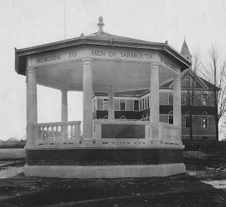
Veterans’ Day evokes memories of Yarmouth’s war memorial bandstand that once stood on the village green.

 In honor of Veterans Day, my focus is on a lost treasure that once graced Yarmouth’s village green, approximately where cars now park in front of the town hall. I’m particularly interested in the date of this year’s holiday (11-11-11) because it carries some hefty historical baggage. In the past there were disagreements about whether a day to celebrate all veterans should be focused on November 11th– which marked specifically the end of World War I. From my perspective this year’s date brings us back to the old time view that the WWI armistice took effect precisely at “the eleventh hour of the eleventh day of the eleventh month.” This was the moment when terrifying guns of World War I finally fell silent. It’s also why Veterans Day was originally called Armistice Day, at least until 1954 when the holiday was broadened to include the veterans of World War II and Korea.

This elegant bandstand was Yarmouth’s war memorial from 1922 to 1953.
The last days of WWI were the most difficult for Yarmouth. One Yarmouth vet, Ernest Storer, was wounded only hours before the truce went into effect. More tragically the town was ravaged that fall by the Spanish Influenza epidemic that killed two Yarmouth soldiers at Ft. Devens. Another fourteen citizens died of the flu in the weeks leading up to the armistice. To make matters worse, there were also two demoralizing false reports on October 11th and November 7th that a truce had gone into effect. Church bells finally rang all day on November 11th 1918 when news was received that the war was truly over. The steam whistles on the pulp mill and sardine cannery let loose their screaming blasts and impromptu parades went up and down Main Street. Of the 107 Yarmouth men that served in WWI, there were three who died and four who returned as veterans wounded in combat.

The town moved quickly to honor its war veterans, a gesture that its dwindling survivors of the Civil War had unsuccessfully advocated for over fifty years. The result was an elegantly designed bandstand that was erected in 1922 in front of the high school and central elementary school that were then located on Main Street opposite the Merrill library. Bearing a plaque dedicated to all Yarmouth servicemen from the Revolution through WWI, the bandstand was an exceptionally appropriate way to honor the veterans. In its very structure and use, the bandstand created a kind of living memorial around which town residents could gather on warm summer nights to hear performances by the legendary Yarmouth band. Located right in front of the schools, it also kept the town’s patriotic heritage directly in the sights of its young people. If you look closely at the picture, you will also see the elements of classical Greek design with eight Doric columns, urn-like balusters and a delicate finial on the roof. Homer got it right. The Greeks knew how to honor the valor of their warriors. The classical style of the bandstand made this a superb memorial for Yarmouth’s war veterans.

However, there was more than patriotic sentiment that pushed this project rapidly forward. Civic progressives such as George Hammond in the 1890’s had been trying to create a true town center to bind together the two distinct halves of 19th century Yarmouth. Between the upper and lower villages (“the Corner” and “the Falls”) was a muddy valley commonly known as Brickyard Hollow. By rebranding this area as “Centerville” and filling the valley with pulp mill ash, they created a space for the new library and centralized schools. During WWI that effort had stalled, leaving several dilapidated private buildings to soak up the floods caused by melting snow and Cleaves Brook. Although past efforts to have the town buy that property had been defeated, it was finally acquired and the buildings auctioned off by the town in 1921––very likely with more popular support because of the proposed new war memorial.

If the town had dithered for another year, the bandstand might never have been built. In 1923 the Forest Paper Company abruptly shut down, laying off the majority of the town’s industrial workers. With the passing of shipbuilding, shoe manufacturing and now the pulp mill, the Great Depression came early to Yarmouth and lasted longer. Perhaps these harsh economic realities also explain why the town did not adequately maintain its elegant little bandbox. Rotting and falling apart, the memorial became an eyesore that threatened the safety of the school children. Carl Winslow recalls that it in its final days the bandstand was wrapped in snow fencing to keep kids from climbing into it. The memorial was demolished around 1953 and its brass plaque was relocated to the nearby American Legion’s log cabin where it remains to this day. Personally, I think the town should dust off the plaque and rebuild its little bandstand right by the flagpole on the village green. With its Doric columns and balustrades, the bandstand would harmonize beautifully with the classical style of the town hall and create an elegant focal point for the civic culture of Yarmouth.

Today’s photograph of the bandstand is from the collection of the Yarmouth Historical Society. The picture posted below is from my own collection and it shows how difficult it was to turn Brickyard Hollow into the town's village green. Floods of this sort lasted into the 1980's when the town finally installed huge drains to carry the water past the library and under Bennett Field to drain into the Royal River. Many local residents have memories of emergency book brigades trying to rescue books from the lower level of the library.

Tuesday, October 18, 2011

Enthusiasm for clipper ships sometimes leaves our local maritime heritage in a fog bank.

 My focus today is on clipper ship mythology, which I think has something in common with being a Boston Red Socks fan. When life’s facts don’t quite square with what we deeply believe should happen, we bury the results in a cloud of wishful thinking. I learned this truth the hard way when I started giving local history lectures thirty years ago. Armed with a freshly minted graduate degree in history, it never dawned on me that people would cling to their cherished view of the past even after I showed them my evidence to the contrary. It’s unfortunate how often there’s simply no evidence whatsoever to back up claims that a house once had an Indian tunnel or that it was a key stop on the underground railroad.

 Although I am now much older and wiser, I still find myself in the delicate position of trying to nudge people toward a more accurate understanding of the past. In Yarmouth for example, where the local sports teams are called the “Clippers,” it is amusingly awkward to point out that clipper ships were never part of the local maritime heritage. In the 19th century, Yarmouth’s shipbuilders were smart enough to foresee that clipper ships would be a bad investment. Realizing that clippers required huge crews and usually carried far less cargo in their slender hulls, the local shipbuilders did the math. They focused on sensible cargo carriers like “downeasters” with good speed and the potential for great profits. Unfortunately, the town’s clipper mythology was taken to a new level this summer when a rather odd-looking sculpture of a “clipper ship” abruptly came ashore on the lawn of Yarmouth High School. Instead of evoking the cloudlike beauty of a clipper ship’s sails, the statue’s rigging seems to have more in common with a Viking ship burial.
The San Joaquin appears in several history books as the Tam O’Shanter.
 I have encountered a different version of this problem in regard to Freeport’s maritime history. For more than a century the citizens of the town have enthusiastically kept alive the heritage of one of their own “downeasters”–the Tam O’Shanter. In fact the Freeport Historical Society recently put together a superb year long celebration of the Tam with an exhibition, lectures, concerts and performances. Often described as a “near clipper,” the Tam was fast, beautiful and highly profitable with a johnboat full of colorful stories and sea captains trailing in her wake. The Tam’s legend has loomed so large over the town’s maritime history that the ship has become the face of that heritage, crowding out nearly all of the others except for the heroic War of 1812 privateer, the Dash.

 Unfortunately, at some point in the last century some of the local residents showed more enthusiasm than accuracy in their recollections of great ship. The name Tam O’Shanter sometimes became the default when people were trying to label unidentified photographs of Freeport ships. For example, I found a picture of the John A. Briggs, the largest vessel ever launched in South Freeport, with the label “Tama Shanta” crossed out on the back of it. I want to thank Ned Allen, the curator of the Freeport Historical Society and also Dave Coffin, the great grandson of the Tam’s last captain, for helping to steer me straight regarding images of the Tam.

 Unfortunately, this wishful thinking about the Tam did not remain on the back of a few old photos. They worked their way into the very bones of the town’s history. An image of the Tam’s sister ship, the San Joaquin suddenly became the Tam O’Shanter when it was published in the town’s classic history, Three Centuries of Freeport. More recently, that same mistake was carried over into the Arcadia publication, Images of America: Freeport. In pointing this out, I’m not trying to be critical of these books that I regularly consult. I’m just emphasizing the perils of wishful thinking in local history.

 In today’s photograph we see the San Joaquin captured in 1876 just before its launch from the Soule shipyard in South Freeport. As the very next ship to be built by E.C. Soule after the launch of the Tam in 1875, it is not surprising that the two vessels were very similar. The major difference involves the position of the steering wheel. On the Tam it was located forward of the little deck house on the ship’s stern. In this photo of the San Joaquin the wheel is located aft of the little deck house.

 In the 1870’s and 1880’s both ships carried California grain and cargoes from Asia around Cape Horn to places like New York and Liverpool. It was on one of these difficult voyages that the San Joaquin rammed into an immense ice berg that was nearly ten miles long. Although the force of the collision toppled the forward mast and smashed the bow, the resourceful Captain Larabee jury rigged some repairs and coaxed the wounded ship back to Portland.

 I will return to stories about legendary Tam O’Shanter in future columns. In the meantime, I recommend that you stop by the Freeport Historical Society if you want to find out more about the town’s maritime history. A treasure trove of documents relating to voyages of the Tam and the San Joaquin have been archived from an extensive collection of Soule shipping papers donated by the late Margaret Soule.

Sunday, October 9, 2011

Yarmouth’s shipyards which reached their peak in the 1870’s are now mostly buried under the interstate highway.

 Many years ago I asked a group of Yarmouth High School students if they could imagine what their town’s snug little harbor would look like if it did not have an interstate bridge crouching on top of it. Shrugging off my suggestions about Camden and Kennebunkport, the students concluded that they just couldn’t see it. Today’s photograph brings back to life key parts of the town’s heritage that ended up under that highway bridge. The photo is also a beautifully composed image. The willow tree on the left plays off against a whole series of diagonal lines that lead you to the buildings and ships in the background.

This rooftop view of Yarmouth’s waterfront was probably taken by Charles G. Gooding in the spring of 1874, looking south in the direction of what is now the Yankee Marina on the opposite shore. The date is significant because the 1870’s represented the high water mark of wooden shipbuilding in Yarmouth. Although the scene is eerily deserted, you can see two shipyards and six different vessels in various stages of construction.

Yarmouth's shipyards were at their peak in the 1870's.

In the foreground the Hutchins and Stubbs shipyard may not look very prosperous with its heaps of scrap lumber, but they actually set a record in 1874 by launching four ships. The historian William Rowe described those ships as “modest in size, but famous for the grace and beauty of their lines.” Given the very tight schedule to construct those ships and the fact that no workers are swarming around the newly laid keel in the center of the picture, the photograph was almost certainly taken on a Sunday morning. As soon as one ship was decked over and caulked, the yard would launch it and move the vessel to a finishing pier where the cabin joinery and other details could be completed. This freed up space on the ways to lay the keel of the next ship. The three masts above the tree line in the center of the picture very likely belong to the barkentine Hattie S. Jackson that Hutchins and Stubbs is known to have completed at Union Wharf in 1874.

Tucked into the lower right corner of the picture is a rough shed that housed the shipyard’s blacksmith shop and a boiler that was used to steam the long planks so they would bend into the shape of the vessel’s hull. On the wall of the shed facing Lafayette Street you can see advertising signs for products like health tonics and Florence sewing machines. Bob Collins, a colorful old timer on Yarmouth’s waterfront, once told me that the clump of willows on the left shaded a spring that was used by the shipyard workers.

Jutting across the middle of the Hutchins and Stubbs yard, you can see the long white keel of the bark Tewksbury L. Swett.. In 1889, during a voyage from New Zealand to Hong Kong, this vessel was hurled by a typhoon onto a reef. After much hardship the crew reached one of the Caroline Islands where they were robbed and held for ransom by a conniving local tribe. Captain William H. Gooding was eventually able to convince the chief that his tribe might face severe retribution if they harmed their captives. When he finally arrived home nearly a year later, he discovered that nearly everyone assumed he was dead and the insurance company was trying hard to convince his wife to accept that fact. Although this event was later overstated into “a narrow escape from cannibals,” it still demonstrates the extraordinary dangers faced by Yarmouth ships and sailors.

Returning again to our photograph, a row of commercial buildings on Central Wharf separates the Hutchins and Stubbs shipyard from Union Wharf where the ship C..F. Sargent is being built in the Blanchard shipyard. Although two of these buildings were originally constructed as warehouses, the Yarmouth ships of the 1860’s and 1870’s were so big that they were never intended to carry their cargoes of wheat and cotton back to the shallow Royal River where they were born. The oldest warehouse, built for the West India trade, ended up holding local products like hay and pottery for small coastal schooners. The little building on the right was Sawyer’s fish market which had a huge iron kettle for boiling lobsters. In the 1870’s a nickel would buy one of those lobsters!

In a future column I will return to the bold, innovative and somewhat ill-fated efforts of the Blanchards, Yarmouth’s most well known family of sea captains and shipbuilders. Several of their largest ships were lost before they could return a profit to the family. Others, like the C.F. Sargent which is under construction in this picture, had narrow escapes from disaster. A tsunami nearly destroyed the Sargent when she was loaded with guano and ready to sail from a Peruvian seaport. According to Rowe, the ship “rose on the crest of the wave and spun like a top on the sea.” Miraculously the staunchly built vessel survived to sail another day––much like her namesake the merchant Cyrus F. Sargent who was briefly detained for treasonous pro-Southern sympathies shortly after the Civil War broke out.

If you are intrigued by pictures and stories such as these, I encourage you to visit the Yarmouth Historical Society. You can find them in person on the top floor of the town library or you can visit them online at http://www.yarmouthmehistory.org/. Because they have some very exciting plans to relocate their museum and research facilities to the old Water District building on East Elm Street, I will soon share with you some wonderful photographs of what that area looked like a century ago.

The unique Cribstone Bridge to Bailey’s Island was born out of a blood feud but it is now a cherished symbol of Harpswell.

 Since it is summertime in Casco Bay, many readers of The Notes will travel over or under this famous Bailey’s Island landmark that has just survived three years of rehabilitation by the Department of Transportation. As a resident of Orr’s Island, I can attest that all three of the Rt. 24 bridges from Cook’s Corner to Bailey’s Island offer dangerously distracting views in opposite directions. To add to the fun, two of the bridges take sudden dips and curves as they follow the original line of ledges. Then the road suddenly rises up to leave a little headroom for fishing boats. In fact, you might want to hold off texting how pretty it is until you’ve cleared the SAD 75 school bus that’s probably on the bridge with you. 

 In 1821 the northern end of Orr’s Island was linked by a bridge and causeway to Great Island––more than a century before the cribstone bridge connected the southern end of Orr’s to Bailey’s Island in 1928. This delay was no accident. In a small town like Harpswell, costly proposals that involve major changes in how things get done are guaranteed to rile up a whole string of town meetings. Consider, for example, the recent dust ups over constructing an L.N.G. terminal and consolidating the town’s two schools. 
The unique design of the granite cleverly absorbs the force of ocean waves and
reduces the current flowing through the main channel.
 The first serious design for a bridge to Bailey’s Island was drawn up in 1880 by George L.Vose who was highly respected as a professor of civil engineering at Bowdoin. It was Vose who rejected the popular notion that the bridge had be constructed of local stone combined with sections perched on driven piles. He argued that piles could not be driven into the ledges that fringe Will’s Gut and that the local stone was unsuitable for the causeway because it was “too friable.” He went on to suggest that curving the bridge to follow the inner line of ledges would reduce the amount of granite needed for the causeway.


 Over the next forty years, the arguments for and against the bridge were so intense that the issue had to resolved in court several times. Harpswell historian Richard Wescott called it a blood feud. Understandably, the voters on Bailey’s Island were generally in favor of the bridge, while other folks argued it was simply too expensive for a small town to finance such a big project. Nevertheless, by the 1920’s popular support began to shift toward the bridge. Gasoline engines not only brought a flood of tourists, but they also made it possible for fishermen to put out to sea without having to carry a sailing rig through Will’s Gut. In addition, state and county financing for big transportation projects became available after 1920.


 In 1926 and 1927 the cribstone bridge was pieced together out of Pownal granite that was hauled to a landing on the Cousins River in Yarmouth (now the site of the Muddy Rudder restaurant). Frank Knight, who is 102, told me that he worked on this project and that the same vein of granite used for the bridge was also used to construct Yarmouth’s Catholic Church.


 The final design of the bridge closely followed Vose’s original plan, but it reduced the number of openings through the span from three to one. The distinctive criss-cross of granite slabs (the “cribstones”) allows the tide to swirl through the bridge instead of acting like a huge dam and sluiceway. This greatly reduces the impact of storm surges and also considerably weakens the intensity of the current that flows through the single narrow opening. In this way the unique design of the bridge works with nature instead of fighting every big green wave that rolls in from the North Atlantic. Personally, I also like the fact that not long after you cross the cribstone bridge, the highway comes to an abrupt end. In an age of endless choices and committees to discuss options, there is something refreshing and unambiguous about a road that simply stops in the ocean. When it comes to life on islands, the sea always gets the final word.

Friday, September 30, 2011

Hidden along the banks of the Harraseeket River Pettengill Farm is a house full of very old secrets

Although I enjoy researching and writing about history, I love it when history simply smacks me in the face. For example, I didn’t know anything about Freeport’s lovely Pettengill Farm until one gorgeous summer day in 1974 when it suddenly loomed over my head and announced its presence. At the time I was living on Staples Point near the Harraseeket River and enjoyed canoeing far up into the tidal streams near Mast Landing.
The Pettengill House in Freeport is a treasure that has survived for over 200 years without ever being"modernized" with electricity or indoor plumbing.

 What I saw on that hill overlooking my canoe looked like a movie set for colonial Salem. In the photograph you can see the northwest corner of the Pettengill House. The long sloping roof of its “saltbox” style was designed to carry the cold north wind up and away from the farmhouse while the double row of windows on the southern facade invited in the sunshine. What we now describe as a clever bit of passive solar engineering was probably just viewed as common sense in the old days.
The more I learned about the Pettengill House, the more mysterious it became. The saltbox style suggested a home from the late 17th to mid 18th century, but I discovered that all of the earliest settlers’ homes in what is now the Yarmouth and Freeport area were destroyed in a series of bloody Indian wars in the 1670’s and 1680’s. When these early homes were abandoned or burned, their owners fled to Boston if they were lucky.
 
 An archaeological dig at the Pettengill farm in 1978 confirmed that an older building did occupy the site in the late 1600’s and was destroyed by fire. This interrupted settlement pattern meant that many decades later when settlers returned to the area, they were more likely to use newer architectural styles such as Georgian/Colonial. When Joseph and Aaron Lufkin built the current Pettengill house around 1800, they were apparently influenced by the old saltbox homes they had known in Gloucester, Massachusetts where they had grown up. 
Around 1850 a Porters Landing sea captain and store owner named Charles Pettengill bought the farm and 120 acres. After 1925 the farm was being run by his grandchildren Frank and Millie Pettengill, neither of whom ever married. They eked out a subsistence lifestyle, raising their own food and earning cash mostly from the sale of milk. They plowed their fields with a horse and cut their own ice in the winter. Millie walked everywhere to collect local plants and combined them into beautiful flower gardens.

 Unfortunately, as they grew older, it became much more difficult for Frank and Millie to live by themselves in a house that was heated only by wood and never modernized with plumbing and electricity. In 1959, their situation attracted the attention of Lawrence M.C. Smith and his wife Eleanor who offered the Pettengills a kind of reverse mortgage. The arrangement gave Frank and Millie some financial security and the right to live at the farm even though the title to the land passed to the Smiths.

Before she died at the age of 98, Millie told the Smiths about another mysterious feature of the house. She described whales, sea monsters and old sailing ships that were scratched into the plaster walls. This “sgraffitti” as it was called, had been hidden under layers of wallpaper. Oddly enough, these images sometimes refer to events from the War of 1812, which was a time when the house was probably not even occupied. 
Mysterious images scratched on the walls and a secret packet of letters in the attic
add to the mysteries of the Pettengill Farm.

Personally, I think the most fascinating mystery associated with the Pettengill farm is the packet of letters found in the attic after the property was transferred to the Freeport Historical Society. To find out more about Millie’s secret romance and what it was really like to live at the Pettengill Farm, I highly recommend seeing the video Words from Millie’s Garden. This documentary by Ronald J. Gillis is available from the Freeport Historical Society. Visit their website, www.freeporthistoricalsociety.org or stop by their museum at 45 Main Street in Freeport to see what archaeologists have discovered at the Pettengill farm. The current exhibit is called “Diggin’ History: Piecing Together Pettengill Farm’s Past.”

Monday, August 22, 2011

Yarmouth's Old Brick Store

 Today’s column reawakens a very old tradition at The Notes.  For many years, each edition of this paper featured “The Way We Were”--an old photograph from one of the towns covered in its circulation area. Like many local residents, I remember being fascinated by those images and slightly frustrated that their tiny captions didn’t reveal very much. Years later, when I was trying to locate vintage pictures for my photographic history of Yarmouth, I found that the first thing many old time residents would thrust into my hands was a thick folder of yellowed images torn from those old copies of The Notes

 My approach will be little different. Instead relying on a brief caption, I promise to breathe life into each old picture by providing odd bits of historical background and telling stories linked to that image. Eventually, some of my columns will leave you with an occasional “cliffhanger” to encourage you to visit the website of one of the local historical societies in order to find additional stories and photos about that topic.
Source: Collection of Alan Hall

 I’ve chosen today’s photograph because it takes us right back to the origins of The Notes.  Many of you will recognize this old brick store that still exists on Main Street in Yarmouth, near the Baptist Church.  Although dozens of commercial ventures have occupied this location since it was built around 1830, it has a special place in the history of The Notes because it is where Ken Larrabee first edited and published this paper.  Full of energy and opinions, Ken clearly savored his role as a community gadfly.  He and his friends like Phil Shephard and Stan Milton could turn a breakfast at the Downeast restaurant into a full-blown debating society with topics ranging from controlling nuclear arms to controlling the “bloated” town budget.


 But even in his most indignant editorials, Ken’s commentaries were meek compared to a 19th century newspaper publisher who occupied this building.  In the 1830’s a fiery Universalist minister named Zenas Thompson became the scourge of the First Parish Church. Thompson’s newspaper, The Christian Pilot blasted the Congregationalists for their narrow-minded view of salvation and for their habit excommunicating people for things like setting up a dancing school in Yarmouth. Indeed, it was James C. Hill, the owner of the Brick Store at that time, who ignited the dancing school crisis when he rented a house to the Universalists for their dancing school.  After Hill and his wife were excommunicated for promoting indecent behavior, he got even by purchasing a printing press and bringing Zenas Thompson to unleash his attacks on the First Parish.

 Today’s photograph shows the building around 1880.  William Marston’s clothing store on the left was carried on by his son until just about the time that The Notes was founded in 1952. The odd-looking pole on the left side of the photo was an advertisement for Isaac Johnson’s barber shop.  He was an ex-slave who came to Yarmouth after the Civil War.

 The Yarmouth Historical Society has an excellent collection of materials related to today’s story, including the First Parish Church records about the excommunications and a copy of Zenas Thompson’s Christian Pilot declaring the innocence of James Hill.  To find out more about the activities of the Yarmouth Historical Society, visit their website at http://www.yarmouthmehistory.org/.